


LBE submits the local plan for examination
The Council had now submitted the local plan to the Secretary of State for Housing, Communities and Local Government for independent examination. The Council said that over 10,000 responses had been received.
Annette Feeney has been appointed as the independent programme officer. Annette will organise and administer the examination under the Inspector’s guidance. You can contact Annette by e-mail Annette.Feeney@enfield.gov.uk
Finding submissions to Reg-19
The Council have now published the representations made during reg-19. To access the information you must first find the representation number (the so-called “Rep-ID”) in a massive Micro$oft XLSX spreadsheet. The spreadsheet has three separate sheets: two for residents’ responses and the third holding organisations.
To find a representation, first find the representation-ID (column A) and then enter the number into the search box on form https://www.enfield.gov.uk/services/planning/new-enfield-local-plan/elpexamination Note: you must enter the number exactly as is appears in the spreadsheet, include any leading zeros.
The Society’s own representation
The Society submitted a 66 page document [PDF] commenting on 88 plan policies and paragrapahs. [The document is formatted A3 landscape, so is unsuitable for home printing.] You can find our comments on the most contentious parts of the Plan using the following index:
| PL10 (Chase Park) | pages 28–38 |
| PL11 (Crews Hill) | pages 38–42 and 59–63 |
| DE6 (Tall buildings) | pages 45–48 |
| SA URB.03 (Chase Farm) | page 63 |
| SA RUR.02 (Hadley Wood) | page 63 |
| SA RUR.03 (Land west of Rammey Marsh) | page 64 |
| SA RUR.04 (M25/J24) | page 64 |
In addition to the policies above, we also submitted comments about the Spatial Strategy, the Blue Green Strategy and the Housing Strategy.
Consultants’ reports
The Society commissioned a number of professional consultants to support its arguments about not building on the Green Belt. These are referred-to in our Representation. The reports are available here, as follows:
- Heritage Impact Assessment at site allocations SA11.1, SA11.3 & SA11.5 (Crews Hill)
- Enplan report on draft policies PL9, PL10, PL11, DE11 and DE5
- Enplan-report-landscape-supporting-graphics.pdf
- ACTA Report on heritage and historic landscapes
Council’s Regulation 22 Consultation Statement
LBE have published another mega-document, this time 688 pages, which is their Consultation Statement. It contains a summary of responses received at Regulation-18, Regulation-19 and the changes made to the Local Plan between 18 and 19. The document also include the Council’s response to specific comments made by a number of consultees, including The Enfield Society.
Analysis of the Regulation-19 responses made via this website
We’ve cranked the handle with our old-fashioned difference engine (actually a Tcl script) and come up with the follow information concerning the submissions made through our web-form between 28th March and 10:00 20th May.
Summary
| Submissions | 4088 |
| Individual comments on parts of the Plan | 7054 |
| Distinct people making submissions | 2998 |
| Different postal districts | 161 |
| Date at which half the submissions were made | 15th May |
Top parts of the Plan receiving comments
| PL10 (Chase Park) | 1900 |
| PL11 (Crews Hill) | 1689 |
| SA10.1 (Trent Park Equestrian Centre) | 884 |
| DE6 Area2 (Enfield Town) | 667 |
| DE6 Area1 (Cockfosters) | 285 |
| SA RUR.04 (M25/J24) | 264 |
| SA RUR.02 (Hadley Wood) | 247 |
| SA URB.03 (Chase Farm) | 227 |
| DE6 Area8 (Southgate) | 242 |
| DE6 Area6 (Palmers Green) | 213 |
| SA RUR.03 (Land west of Rammey Marsh) | 201 |
| SA URB.22 (Oakwood station carpark) | 176 |
Top postal districts making submissions
| EN2 | 1971 |
| EN1 | 484 |
| N21 | 424 |
| N14 | 336 |
| EN4 | 141 |
| EN6 | 102 |
| N13 | 99 |
| EN3 | 82 |
| N9 | 48 |
| EN7 | 38 |
| N11 | 30 |
| EN8 | 22 |
| EN5 | 21 |
More about the Plan
The Local Plan runs to about 600 pages, with a further 7,000 pages of evidence which justifies the policies included in the Plan. One of the more important evidence documents is the Green Belt Exceptional Circumstances Topic Paper which sets out the Council’s justification for proposing 10,000 homes on the Green Belt. You can find the links to the Plan on the Council website.
One of the arguments from The Council is that there is insufficient brownfield sites in the Borough to satisfy the housing need, which the Plan states is at least 33,280. Part of the problem with assessing housing need is that the London Plan only covers the period until 2029 and there are a number of different approaches to be used after that date.
The Society and Enfield RoadWatch also question that there are insufficient brownfield locations. in 2019 we worked with the CPRE and produced a report entitled Space to Build which identified locations for over 37,000 dwellings.
The expected timetable is as follows:
- Regulation 19 will end at 23:59BST on Monday 20th May 2024,
- Later in 2024: Examination in Public, with a Planning Inspector appointed by the Secretary of State.
Council Meeting 19th March
At a noisy, and at times bad-tempered, Council meeting on Tuesday 19th March, the Council approved the draft Local Plan by 33 votes to 22. You can watch a recording of the Full Council meeting (running time 3h 18m) via the LBE website. Note: there is no audio for the first 25 minutes of the recording. The final statement by the Leader, Cllr Caliskan, is at time index 3h 07m and the roll-call of Councillors voting can be viewed at time index 3h 13m.
Our objections
These are the areas of concern in the Plan:
Policy PL10: Chase Park (Vicarage Farm) including Land South of Enfield Road and the Trent Park Equestrian Centre
| Local Plan ref | https://www.enfield.gov.uk/__data/assets/pdf_file/0030/55668/ELP-REG19-Consult-Chapters-3-15-Planning.pdf page 89 |
| Site allocations | SA10.1 – 4 https://www.enfield.gov.uk/__data/assets/pdf_file/0031/55669/ELP-Reg19-Appendix-C-Site-Allocations-Planning.pdf page 436 |
| Homes proposed | Total of 3755 |
| Our objections | High level of harm to the character and identity of the area arising from the loss of countryside and semi-rural character Green Belt countryside designated as an Enfield Chase Area of Special Character within the current statutory Development Plan Loss of an important part of the historic landscape of Enfield Chase Urbanisation of the Merryhills Way, a popular Public Right of Way established comparatively recently to provide easy access on foot to high quality countryside Impact on Trent Park Conservation area from development at the Equestrian Centre Urbanisation of countryside views across Enfield Chase from the footpaths along the edge of Williams Wood and Shaws Wood Likely to be car-dominated with few jobs in the area and steep slopes making cycling hard Urbanisation of views from the London Loop public footpath/right of way |

Policy PL11: Crews Hill
| Local Plan ref | https://www.enfield.gov.uk/__data/assets/pdf_file/0030/55668/ELP-REG19-Consult-Chapters-3-15-Planning.pdf page 103 |
| Site allocations | SA11.1–6 https://www.enfield.gov.uk/__data/assets/pdf_file/0031/55669/ELP-Reg19-Appendix-C-Site-Allocations-Planning.pdf page 444 |
| Homes proposed | Total proposed 5,500 |
| Our Objections | Impact on the designated Sites of Importance for Nature Conservation at Crews Hill Golf Course and Glasgow Stud Urbanisation of the setting of the Chain Walk Public Right of Way and Burnt Farm Ride Public Bridleway Impact on views from the Ridgeway across Enfield Chase historic landscape Possible future impact of development from deletion of Green Belt at Kings Oak Plain, an area of countryside recently planted with trees by volunteers Loss of popular garden centres and supporting businesses Harm to the rural setting of the Whitewebbs Transport Museum Traffic pressure harming the character of narrow rural lanes including Whitewebbs Road, Cattlegate Road and East Lodge Lane Traffic pressure on the Conservation Areas at Clay Hill and Forty Hall Likely to be car-dominated with few jobs in the area and steep slopes making cycling hard |

Site Allocation SA URB.03 Chase Farm
| Local Plan ref | https://www.enfield.gov.uk/__data/assets/pdf_file/0031/55669/ELP-Reg19-Appendix-C-Site-Allocations-Planning.pdf page 461 |
| Detail | Plan has no protection for remaining former buildings of the hospital, including the clock-tower. |
| Our Objections | No protection for the historic Clock Tower and associated historic buildings fronting the Ridgeway. |
Tall Buildings Policy DE6: Area 1 Cockfosters
| Local Plan ref | https://www.enfield.gov.uk/__data/assets/pdf_file/0021/55038/ELP-REG19-Appendix-D-Planning.pdf page 564 |
| Detail | Two sites in very close proximity to Cockfosters underground station, both up to 39m. |
| Our Objections | Impact on views from Trent Park Conservation Area Impact on the character of the Cockfosters Impacts on views from across a wide area of historic Enfield Chase Area of Special Character/countryside |
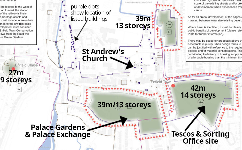
Tall Buildings Policy DE6: Area 2 Enfield Town
| Local Plan ref | https://www.enfield.gov.uk/__data/assets/pdf_file/0021/55038/ELP-REG19-Appendix-D-Planning.pdf page 565 |
| Detail | Four sites are identified as follows: Enfield Chase Station (27m); Palace Gardens/Exchange (39m); Tesco’s/Sorting Office (42m) and Civic Centre (39m). |
| Our Objections | Impact on the historic market town character of the Enfield town Conservation Area Impact on the historic market square and numerous listed buildings including St Andrews church |
Tall Buildings Policy DE6: Area 6 Southgate
| Local Plan ref | https://www.enfield.gov.uk/__data/assets/pdf_file/0021/55038/ELP-REG19-Appendix-D-Planning.pdf page 569 |
| Detail | Four sites are indicated around Southgate Circus with a maximum height of 30m |
| Our Objections | on a hill and will dominate the view across a wide area will overshadow surrounding residential properties will dominate the Grade II Listed Holden underground station. |
Tall Buildings Policy DE6: Area 8 Palmers Green
| Local Plan ref | https://www.enfield.gov.uk/__data/assets/pdf_file/0021/55038/ELP-REG19-Appendix-D-Planning.pdf page 571 |
| Detail | The current site of Morrisons is indicated, with a maximum height of 24m. |
| Our Objections | Impact on setting of the Lakes Estate Conservation Area Impact on the setting of Broomfield Park and site of Broomfield House |
Site SA RUR.02: Hadley Wood (Land Between Camlet Way and Crescent Way)
| Local Plan ref | https://www.enfield.gov.uk/__data/assets/pdf_file/0031/55669/ELP-Reg19-Appendix-C-Site-Allocations-Planning.pdf page 511 |
| Detail | SA RUR.02: 160 houses |
| Our Objections | Green Belt countryside designated as an Enfield Chase Area of Special Character within the current statutory Development Plan Impact on the setting of Conservation Areas at Hadley Wood and Monken Hadley (Barnet) |
Site SA RUR.03: Land west of Rammey March
| Local Plan ref | https://www.enfield.gov.uk/__data/assets/pdf_file/0031/55669/ELP-Reg19-Appendix-C-Site-Allocations-Planning.pdf page 540 |
| Detail | Proposed at least 70,200 sq m of new employment floorspace (light industrial, general industrial, storage and distribution, and related sui generis) floorspace |
| Our Objections | Green Belt designated as part of the Lee Valley Area of Special Character Non-designated wildlife-rich area |
Site SA RUR.04: M25 Junction 24 (The Ridgeway, near St John’s school)
| Local Plan ref | https://www.enfield.gov.uk/__data/assets/pdf_file/0031/55669/ELP-Reg19-Appendix-C-Site-Allocations-Planning.pdf page 542 |
| Detail | SA RUR.04: Proposed 30,550 sqm of general industrial, storage and distribution |
| Our Objections | Harm to green gateway to the Borough Green Belt countryside designated as an Enfield Chase Area of Special Character within the current statutory Development Plan |
The 2021 Version
The Council published a draft of the Local Plan in the Summer of 2021 and ran a 12-week “regulation 18” consultation. More details can be found here.
See Also
- The Society’s response to the 2021 draft
- The Extraordinary Story of Enfield Chase
- The Society’s concern for Enfield Chase
- 2021 Consultation response index
You might like to explore some of the areas affected by proposals in the Local Plan. We have a series of described walks across Enfield Chase which you can download and follow at your leisure.