This article by Stephen Gilburt was first published by The Enfield Society in two parts; before 1914 in newsletter 220, Winter 2020 and after 1914, in newsletter 221, Spring 2021.
Introduction
The name of the manor of Edmonton appears as Delmetone or Adelmetone (Eadhelm’s Farm) in the Domesday Book of 1086. The manor was given by William the Conqueror to Geoffrey de Mandeville and was later purchased by Henry VIII. Edmonton Green lay on the main road north from London to Waltham Cross, between Fore Street to the south and Hertford Road to the north, at the junction with Church Street which led to All Saints Church (see Newsletter 178 Summer 2010) and to Enfield Town. In the 18th century Edmonton was famous for its fair for hiring servants and the village was popular with wealthy citizens from London seeking a pleasant place to live.
Before the Northern and Eastern Railway built a line along the Lea Valley in 1840, and a branch line through Edmonton Green to Enfield Town was opened by the Enfield and Edmonton Railway Company in 1849, there was a horse bus service at 15 minute intervals between Edmonton and the City of London. In 1872 the Great Eastern Railway constructed a direct line from central London via Hackney Downs and Lower Edmonton to Enfield Town. The nature of the area changed when cheap fares on workmen’s trains led to a large numbers of working class dwellings being erected in Edmonton. Horse drawn trams arrived in Edmonton in 1881 and the route along Fore Street and Hertford Road to Tramway Avenue was electrified in 1905.
Some Georgian houses, often with Victorian shop fronts inserted, have survived in Church Street (see Newsletter 195 Autumn 2014), Hertford Road and Fore Street (see Newsletter 206 Summer 2017) but those on Edmonton Green were demolished, along with several public houses, when the area was redeveloped between 1965 and 1974.
For more information see: Southgate and Edmonton Past by Graham Dalling 1996; The History of the Parish of Edmonton by Frederick Fisk 1914; The New Enfield, Stories of Enfield, Edmonton and Southgate by David Pam 1977; Edmonton Ancient Village to Working Class Suburb by David Pam 2006; The London Borough of Enfield by Alan Dumayne 1996; Treasures of Enfield, Discovering the Buildings of a London Borough, edited by Valerie Carter 2000; A-Z of Enfield Pubs Part Two by Gary Boudier 2002; Theatres, Music Halls and Cinemas in the London Borough of Enfield by Geoffrey Gillam 1986; The Buildings of England London 4: North by Bridget Cherry and Nikolaus Pevsner 1998; Middlesex by Michael Robbins 1953/2003.
These publications may be consulted at Enfield Local Studies Library and Archives, which also provided the illustrations used in this article.
Before 1914

1. This print of 1806 shows Edmonton Green with Salmons Brook flowing through the rural village on its way to join Pymmes Brook and then the River Lea.

2. This view of Edmonton Green in1904 shows the level crossing, signal and signal box on the 1849 railway line. Edmonton lower level station was to the left of the signal box. Beyond is the triangle of The Green where circuses and fairs were held and travelling salesmen offered their wares. Shops including Dale’s department store can be seen on the far side of The Green.

3. The Cross Keys, by Salmons Brook and the railway line, was built of stone and brick covered with tarred clap-boarding and rough-cast cement and had a pantiled roof. Parts dated back to to the 17th century and it became one of the largest inns in the area. The earliest mention of the inn was in 1680 and the first recorded landlord was in 1716. This view dates from just before the inn was rebuilt in 1886.

4. This view from about 1905 shows the nearby Ragg’s Chemist and Post Office, which was in existence for over 100 years.

5. Mr W.W. Ragg is shown behind his pharmacy counter. The leech jar to the left of the clock face was about 150 years old.

6. This is a view from about 1886 of the east side of The Green looking north towards Hertford Road. In the foreground is Young’s the baker with Beeton’s the butcher further along.

7. This 1899 view of the east side of The Green is looking south from Hertford Road. The man with the dog is Mr. Wise, headmaster of Croyland Road School.

8. This 1912 view looking south from Edmonton Green shows the working class street food market which was established about 1900. Frederick Fisk, in his 1914 ‘The History of the Parish of Edmonton’ states “the roadway round some parts of Edmonton Green is given up on Saturdays to the coster class on whose barrows are displayed for sale goods of nearly every description for the poorer classes”. Edmonton Council tried without success to stop this market. The Exhibition public house on the left was built in 1851, taking its name from the 1851 Great Exhibition in Hyde Park. Further down the road on the left is the Golden Lion which is first recorded in 1521. In the 18th century it was a coaching inn.

9. This 1910 view shows Edmonton Empire music hall in Fore Street which opened in 1908. “Edmonton Empire. This new and beautiful hall. Tip-up seats throughout. Private boxes to hold four for 7s 6d (371/2p). Orchestral stall 1s (5p). Circle 6d (21/2p). Pit 3d (1p). Cycles stored free of charge.” (Enfield Gazette 28 January 1910). Among the performers were the singers Marie Lloyd (whose last performance took place here in 1922 a few days before her death) and Florrie Forde. There were also variety, comedy and juggling acts and films from the Bioscope Company.

10. The east side of Fore Street with a horse drawn tram is shown in this photograph from around 1900. Edmonton Town Hall on the right was opened in 1884, less than three years after Southgate was separated from Edmonton in 1881. In 1903 indoor swimming baths were built behind the Town Hall in Knights Lane. Edmonton became and urban district and a borough in 1937. Next to the Town Hall is Lower Edmonton Congregational Church built in 1883. (It was demolished in 1957 and replaced by a new church further south on Fore Street in 1959).
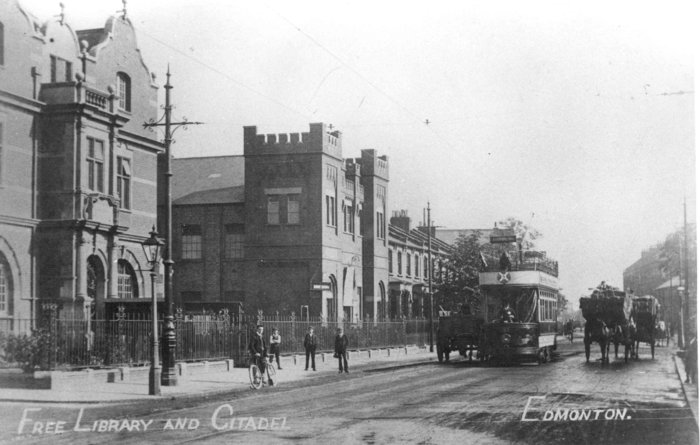
11. On the left in this 1910 view looking north along the west side of Fore Street is the Grade II listed former Passmore Edwards Library by Maurice B. Adams of 1897. (It was extended in 1931 by Cuthbert Brown. It is now a Sikh community centre.) The adjoining building is the Salvation Army Citadel which has since been rebuilt. Open top electric trams were introduced to Fore Street in 1905.
After 1914
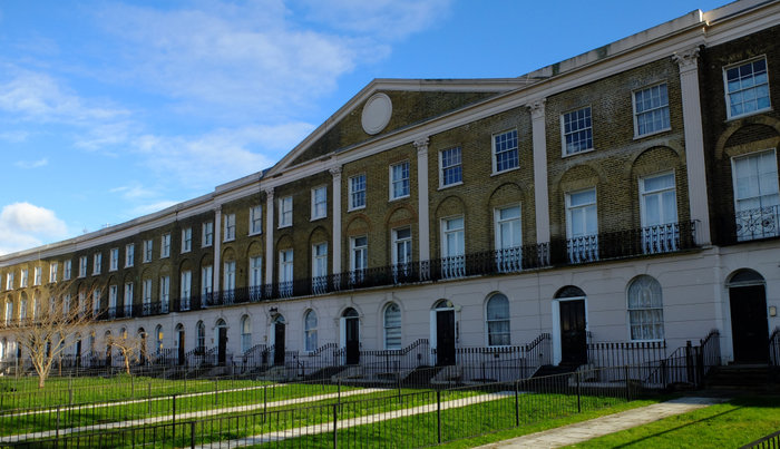
12. Just to the north of Edmonton Green is the Crescent 84-132 Hertford Road, built as a speculation by a London solicitor between 1826 and 1851, although the northern end was not completed. This terrace of brown brick houses with stucco covered ground floors, seen here in 2020, is listed Grade II for its group value and in 2008 was made a conservation area.
Each three storey house with a basement is two windows wide with an arched doorway and ground floor windows. The first floor windows have balconies with cast iron railings and brick arches above. The centre and southern end have tall stucco Corinthian pilasters rising from the first floor.
The terrace has been restored, although the communal grass area and carriage drive at the front have not been reinstated and the area remains divided into separate front gardens.
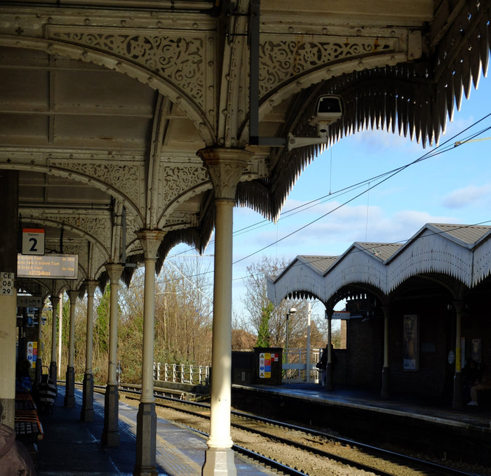
13 Lower Edmonton, now Edmonton Green station on the direct rail route from Liverpool Street to Enfield Town, was constructed by the Great Eastern Railway in 1872. This recent view shows that both platforms have retained their original canopies. The station now has a new ticket office and lifts to the platforms.
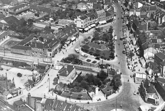
14. This 1934 view from the air looking north shows Edmonton Green which was formed in the triangle between the road from Ponders End at the top and the road from Enfield Town on the left (bottom). The third side of the triangle was marked by Salmon’s Brook and later by the 1849 railway line.
In the foreground can be seen the war memorial constructed in 1924 and the station house for the low-level railway. The line closed to passenger traffic in 1939 and the track was lifted in 1965.
To the left on the far side of the railway line is the Cross Keys inn rebuilt in brick in 1886. It survived the redevelopment of Edmonton Green, but was restructured several times to provide, in turn, a stage and dance floor, a variety theatre and a night club, before being gutted by fire in the 1980s and replaced by a block of flats.
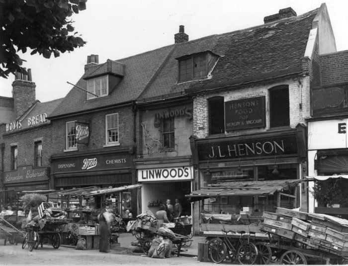
15. Market traders’ carts can be seen in front of the shops in this view of the east side of Edmonton Green in about 1949. From the left are Edmonton Bakeries, Boots dispensing chemists, Linwood’s noted for its fresh fish and Henson’s with “food for health and vigour”.

16. Geary’s baker and pastry cook, seen here in 1949, was established in Lower Edmonton in 1903. to the right is “Tesco Stores Ltd. The Modern Grocers”.
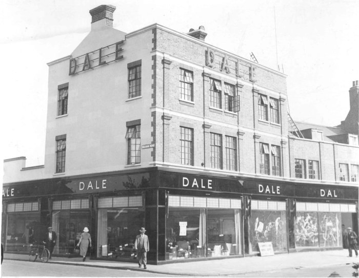
17. This view from around 1955 shows Dale’s department store on the east side of The Green at the junction with Balham Road. It was established in 1851.
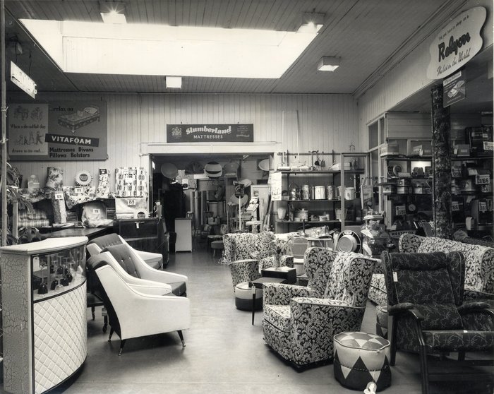
18. This is the furniture department of Dale’s in 1955.

19. This 1961 photograph shows the Golden Lion at 42 The Green. Parts of the building dated back to the 16th or possibly the 15th century. The earliest landlord recorded is in 1521. In the 18th century it was a coaching inn and the archway on the left led to a courtyard with stables and a coach house. In the 19th century the Golden Lion was used as an office by tax officials, Monarch Fire and Life Insurance and Tottenham and Edmonton Association Omnibus. A shop to the right later became an off licence. On the left was Edgley’s butchers.
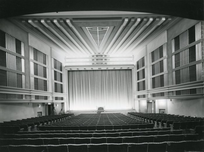
20. The Edmonton Empire music hall opened in 1908. In 1933 it was reconstructed internally to show sound films and the stage was enlarged for live performances. It was renamed the Granada in 1951. In later years it was used for wrestling and bingo but closed in 1968 and was demolished in 1970.

21. New Road was built to take traffic over the 1849 railway line and avoid the level crossing by The Green. Behind the bank and other soon to be demolished buildings in this photograph, which I took in 1970, can be seen a new multi-storey car park and a tower block of flats.
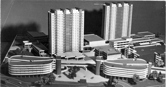
22. This model shows the comprehensive redevelopment plan for Edmonton Green by Frederick Gibberd and Partners, which was agreed in 1960. It included a pedestrian shopping area (which had room for the market traders), spaces for 3000 cars in multi-storey car parks, two tower blocks with 750 flats and new amenity and civic buildings. Following the amalgamation of Edmonton with Southgate and Enfield to form the London Borough of Enfield in 1965, plans for new civic buildings to replace Edmonton town hall were dropped, although a leisure centre was built later. The redevelopment of Edmonton Green was carried out between 1965 and 1974.
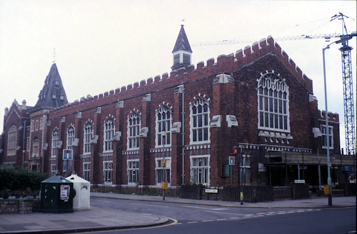
23. This view of Edmonton Town Hall, built in Fore Street in 1884, was taken shortly before it was demolished in 1989.

24. This 2010 view shows the 1924 war memorial now isolated on a traffic roundabout. In the 1990s the former department store was adapted to provide a library and offices. Parts of the earlier development were replaced by lower blocks of flats and two taller blocks at the rear retained. There is now a bus station in front of the flats.


