



This article by Stephen Gilburt was first published by The Enfield Society in newsletter 242, Summer 2026.
Ponders End is thought to take its name from the end of the parish of Enfield in which John Ponder lived in 1373. Ponders Ende is shown on Norden’s 1593 map and John Speed’s 1610 map.
“I had thought in a green old age… to have retired to Ponders End—emblematic name how beautiful!… toddling about between it and Cheshunt”. Charles Lamb wrote this in 1822 to William Wordsworth, when Lamb was still working for the East India Company and living in Islington.
At the beginning of the 19th century Ponders End was a large hamlet. It extended from Red Lane (now Lincoln Road) in the south along the High Street to Farm Lane (now Southbury Road) with houses also in South Street and Scotland Green. A report of 1850 revealed that many of the older cottages were overcrowded and insanitary and that the area suffered from poor drainage. Between 1855 and the 1890s additional houses were built in Alma Road, Napier Road, Derby Road, Lincoln Road, Durants Road and Nags Head Road. However even in 1914 Ponders End was still separated by open country from Enfield Highway to the north, Edmonton to the south and Enfield Town to the west. It was not until 1939 that the gaps had been closed with further housing and industrial development. Since then tower blocks of flats have been built in Alma Road and at the eastern end of South Street.
There was a half-hour coach service to London until a railway was constructed along the Lea Valley in 1840 with a station at Ponders End. What is now Southbury station opened in 1891, when the Southbury loop was constructed.
In 1905 the Metropolitan Electric Tramway electrified the 1881 horse drawn tram route north from Tottenham to a depot at Tramway Avenue in Edmonton. The route was extended through Ponders End to Freezywater in 1906 and Waltham Cross in 1908. A branch along Southbury Road to Enfield Town was opened in 1911. The tram route along Ponders End High Street was converted to trolley bus in 1938 and then to motor bus in 1961.
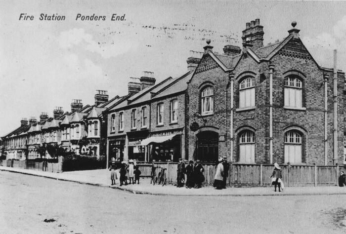
1. Ponders End fire station, at the junction of Nags Head Road with the High Street, operated between 1891 and 1966. It was subsequently an ambulance station. Following demolition in 1987, Vincent House was built on the site.
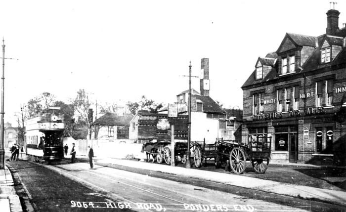
2. An open-top electric tram can be seen on the left in this photograph of the High Street, just south of the junction with Nags Head Road. It dates from about 1907. On the right is the White Hart inn. The first inn on this site is recorded in 1627 making it the earliest in Ponders End. Until the early 20th century there was a brewery next to the inn.
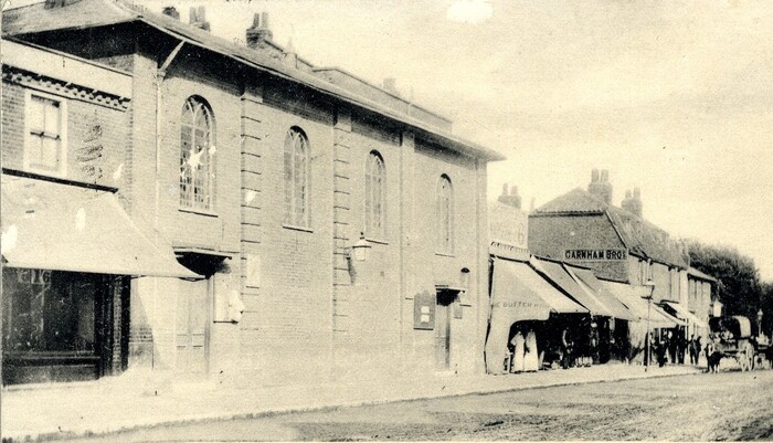
3. The first place of worship in Ponders End was an Independent chapel built in 1757 on the High Street, just north of the junction with Lincoln Road. This brick structure was later covered with Portland cement which was marked out to imitate stone, as shown in this view from around 1904. As Ponders End Congregational Church it was badly damaged by the bomb which fell on the nearby Two Brewers in 1940. It was subsequently demolished and replaced by what is now Ponders End United Reformed Church in
College Court in 1959. The United Reformed Church was formed in 1972 from a union of the Congregational and Presbyterian Churches in England and Wales.
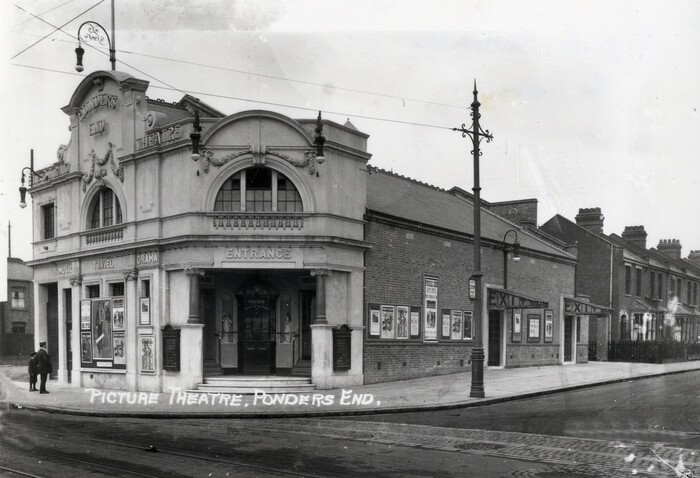
4. The locally listed Picture Palace Electric Theatre opened in 1913 at the junction of the High Street with Lincoln Road. Seats were three pence and six pence. It was later refitted for sound films and renamed The Plaza in 1938 but closed in 1939. Damaged by the nearby bomb in 1940, it remained unused until bought by Enfield Council in the 1950s. It served as a dance hall and community centre known as Howard Hall. I remember going there to hear piano recitals by pupils of Eleanor Franklin Pike. In 2001 it became the Picture Palace public house and more recently a restaurant.
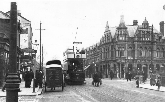
5. The Two Brewers public house, on the corner of the High Street with South Street on the right, is first recorded in 1716 as The Royal Oak. This view from around 1910, with an electric tram on the left, shows it after rebuilding in 1896. It was wrecked by a high explosive bomb, just before closing time, on 30 September 1940. 20 people were killed. The site was not redeveloped and in 2014 a memorial garden, now locally listed, was opened.
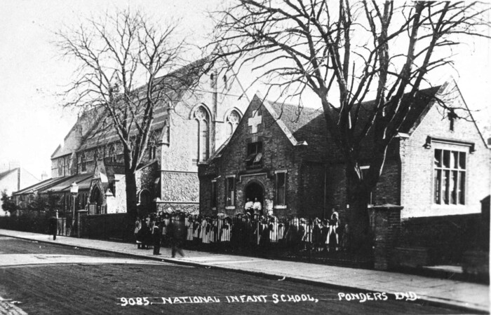
6. Although St James’ Enfield Highway opened in 1831, Ponders End did not have its own Anglican church until 1888 when the nave and north aisle of St Matthew’s opened in South Street The architect was H. J. Paull. The chancel and Lady chapel by J. E. K. and J. P. Cutts were added in 1900. The exterior is of Kentish ragstone with limestone dressings and geometric tracery. It is not currently used for Sunday services. Ponders End National Infants School to the right opened in 1838. It later became St Matthew’s Church of England Primary School. Both church and school are locally listed. A chapel in Alma Road was used by the Roman Catholics before the locally listed St Mary’s Church in Nags Head Road was built in 1921. Today there are also places of worship for other denominations and religions, including a mosque on the High Street.
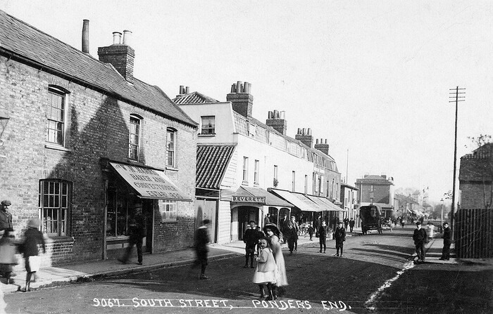
7. This photograph from around 1909 shows South Street, east of the junction with Scotland Green Road. Most of the buildings in this view have since been demolished.
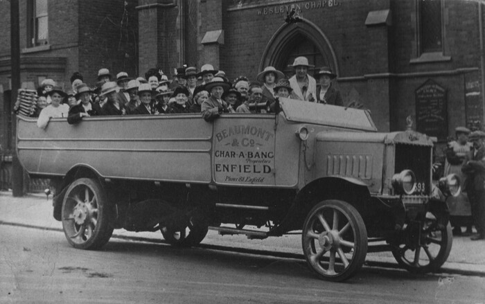
8. This photograph from around 1922 shows a charabanc outing for ladies from the Wesleyan Methodist Church in South Street. The church was originally built for the Baptists in 1891, but was sold to the Methodists in 1895. The building was sold again when the Methodists moved to a new church on the High Street in 1931. The South Street building was eventually demolished in 1969. The Primitive Methodists, Wesleyan Methodists and United Methodists joined together to form the Methodist Church in 1932.
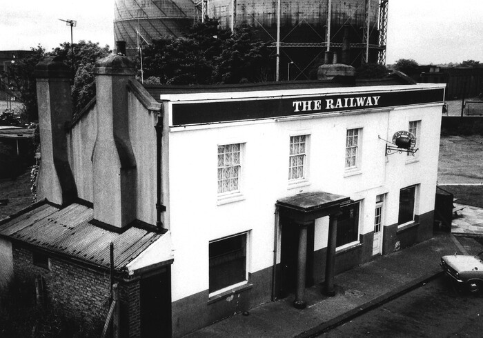
9. The Railway inn in South Street is first recorded in 1841 next to Ponders End railway station, which opened in 1840. It originally consisted of many buildings and included bar areas, a tap room, clubroom, stables, kennels and sheds. Behind was Foresters Music Hall with a stage, lobby area, bar and seating for
250–300 people.
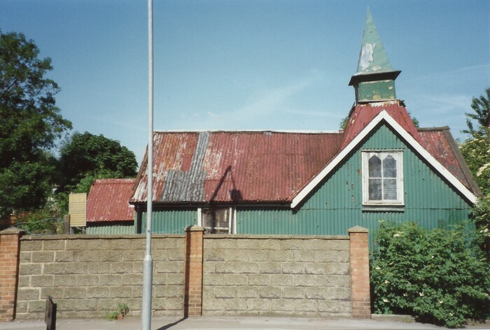
10. The corrugated iron Alma Road Mission was used by Protestant nonconformists up to the late 20th century. A former railway carriage, added to the far side, was used by the Sunday school. In recent years the buildings fell into ruin. Other iron churches were built by the Baptists in Napier Road in 1878 and the Wesleyan Methodists in Alma Road in 1880.
For more information, see the following publications:
- The Buildings of England 4: North by Bridget Cherry and Nikolaus Pevsner 1998
- Britain in Old Photographs: The London Borough of Enfield by Alan Dumayne 1996
- Images of England Enfield compiled by Stephen Sellick 2001
- A History of Enfield by David Pam EPS Volume 1 (before 1837) 1990, Volume 2 (1837–1914) 1992 and Volume 3 (1914–1939) 1994
- Enfield Past by Graham Dalling 1999
- The Enfield Book by Graham Dalling 2007
- Local Heritage List by Enfield Council 2024
- Theatres, Music Halls and Cinemas in the London Borough of Enfield by Geoffrey Gillam 1986
- Ponders End United Reformed Church: A Short History by Peter Cowley 2006
- A Brief History of Methodists in Ponders End by Paul Charters 1993